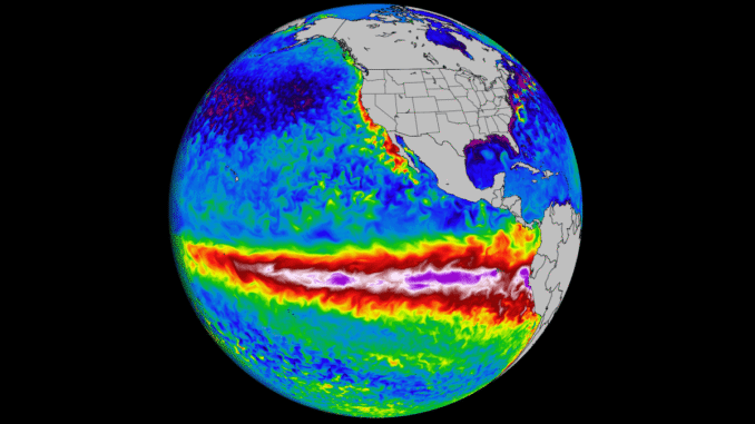
If your Google Trends feed is anything to go by, everyone is suddenly panicking about something called El Niño. The UN’s World Meteorological Organization (WMO) has issued an urgent warning that there is a massive 80% chance of a brand-new El Niño phase officially triggering before September, and a 90% chance it will dominate the rest of the year.
UN Secretary-General António Guterres didn’t mince his words, warning that this climate phenomenon is about to “pour fuel on the fire of a warming world.”
But what actually is it, why is it making a comeback so soon after the devastating 2023-24 cycle, and why should you care? Let’s break it down.
What on Earth is El Niño?
To understand El Niño, you have to look at the Pacific Ocean. Under normal conditions, strong trade winds blow west across the equator, pushing warm surface water from South America toward Asia.
During an El Niño event, those trade winds weaken or completely reverse. Instead of being pushed away, all that warm water sloshes backward, piling up along the western coast of South America.
Think of the Pacific Ocean like a giant hot water bottle. When you move that giant patch of heat thousands of miles to the east, it completely scrambles the global jet stream. The atmospheric engine that drives our daily weather gets knocked entirely out of sync.
Why is it Important right now?
The world only just emerged from a historically powerful “Super El Niño” in early 2024, which broke global temperature records. We then experienced a brief, neutral cooling phase.
Scientists are genuinely alarmed that the ocean is heating back up this quickly. Subsurface temperatures in the tropical Pacific are already tracking up to 6°C above average, creating a massive underground “heat reservoir” that is ready to break out.
The consequences of this rapid shift generally fall into three major buckets:
1. Global Heat on Steroids
El Niño naturally releases immense amounts of ocean heat directly into the atmosphere. Because global baselines are already higher due to climate change, this upcoming cycle means meteorologists are predicting a near-certain, record-shattering hot year before 2030—with a very strong chance that next year will take the crown as the hottest ever recorded in human history.
2. A Tale of Extremes (Drought vs. Deluge)
El Niño changes where rain falls entirely. While it typically suppresses hurricanes in the Atlantic (giving the Americas a slight breather), it supercharges weather elsewhere:
- The Wet Zones: Places like the southern United States, parts of South America, and the Horn of Africa typically face severe flooding, mudslides, and relentless rainfall.
- The Dry Zones: On the flip side, it acts like a giant hair dryer over Australia, Indonesia, Central America, and South Asia—triggering severe droughts and massive wildfire risks.
3. The Price of Your Weekly Shop
This isn’t just a problem for weather geeks; it heavily impacts the global economy. India has already lowered its monsoon rainfall forecasts due to the El Niño timeline. When the Indian monsoon fails or is delayed, global supplies of rice, sugar, and grains take a massive hit. Expect food prices worldwide to fluctuate as agricultural hubs brace for impact.
The British Perspective: If you’re reading this in the UK wondering if you need to buy an air conditioner or a canoe, the honest answer is that El Niño’s direct impact on British weather is notoriously unpredictable. It often leads to colder, drier winters or unusually wet summers depending on how it interacts with Atlantic currents. What is certain is that we will feel the ripple effects through global food supply chains and rising commodity prices.